Real-time flood modelling solution for flood forecasting and emergency management.
H2 Ventures Accelerator, River City Labs Accelerator, Joules Accelerator, Rise accelerator (George Washington University)
Flooding is becoming more frequent and more severe. In the past 10 years, flooding has taken over 56,000 lives in the APAC region. In 2020 over 20 million people were displaced by floods. People lose their homes, become more vulnerable to waterborne diseases and are left unable to work or provide for their families. World Bank's research shows that at least 35% of flood damage is preventable with the right early warning systems. Much loss of life and damage are caused because current flood forecasting systems are too broad and people do not understand that they or their assets are at risk. Flood warnings from government agencies are based on meteorology or hydrology modelling; communicated as a rainfall depth or peak flood height related to a river or catchment. They are presented as a broad map image at a state or national scale. As a result of these outdated and ineffective flood warnings, government agencies, businesses and individuals alike do not have enough warning time for evacuation, or protecting critical assets.
FloodMapp is a world-first real-time flood modelling solution, purpose-built for flood forecasting and emergency management. FloodMapp helps emergency managers prevent loss of life and reduce damage to assets by providing street level, asset specific flood intelligence. With FloodMaps, emergency managers can more efficiently help their communities prepare for, respond to and recover from flooding. Ie provide adequate warning to communities, facilitate targeted evacuations and close flooded roads.
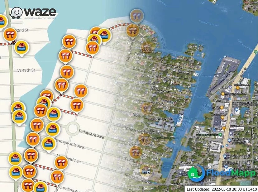
The solution is specifically designed to deliver digital intelligence needed to emergency managers, and subsequently, communities such that they can take action to improve safety and prevent damage. Their technology will help broader communities across the planet adapt to the growing consequences of climate change and prevent billions of dollars of damages and a large number of deaths from happening. This means it can reduce damage to critical infrastructure and avoid disruption of basic services so communities can minimize the costly impact of natural disasters.
Current plans include expansion to countries in Europe, South East Asia, and South America based on inbound interest and enquiries received.