An open-source web-based geospatial ecosystem enabling governments, organizations, and communities to manage, process, visualize, and publish spatial data.
United Nations High Commissioner for Refugees (UNHCR); United Nations Institute for Training and Research (UNITAR); United Nations Industrial Development Organization (UNIDO); UN Open GIS Initiative; Japan International Cooperation Agency (JICA); Ministry of Land, Infrastructure, Transport and Tourism (Japan); The University of Tokyo; FOSS4G community
Governments, municipalities, NGOs and communities increasingly rely on geospatial data for urban planning, disaster preparedness, environmental monitoring and public service delivery. However, existing Geographic Information Systems (GIS) remain expensive, technically complex and fragmented. Proprietary software requires costly licenses and specialized engineering teams, while many open-source alternatives demand advanced technical expertise.
As a result, under-resourced governments and organizations face significant barriers to managing, processing and sharing spatial data. Data often remains siloed across institutions, is difficult to convert between formats, and inaccessible to non-technical users. This limits evidence-based decision-making and prevents communities—particularly in developing and crisis-affected contexts—from leveraging spatial data to support sustainable development and human security.
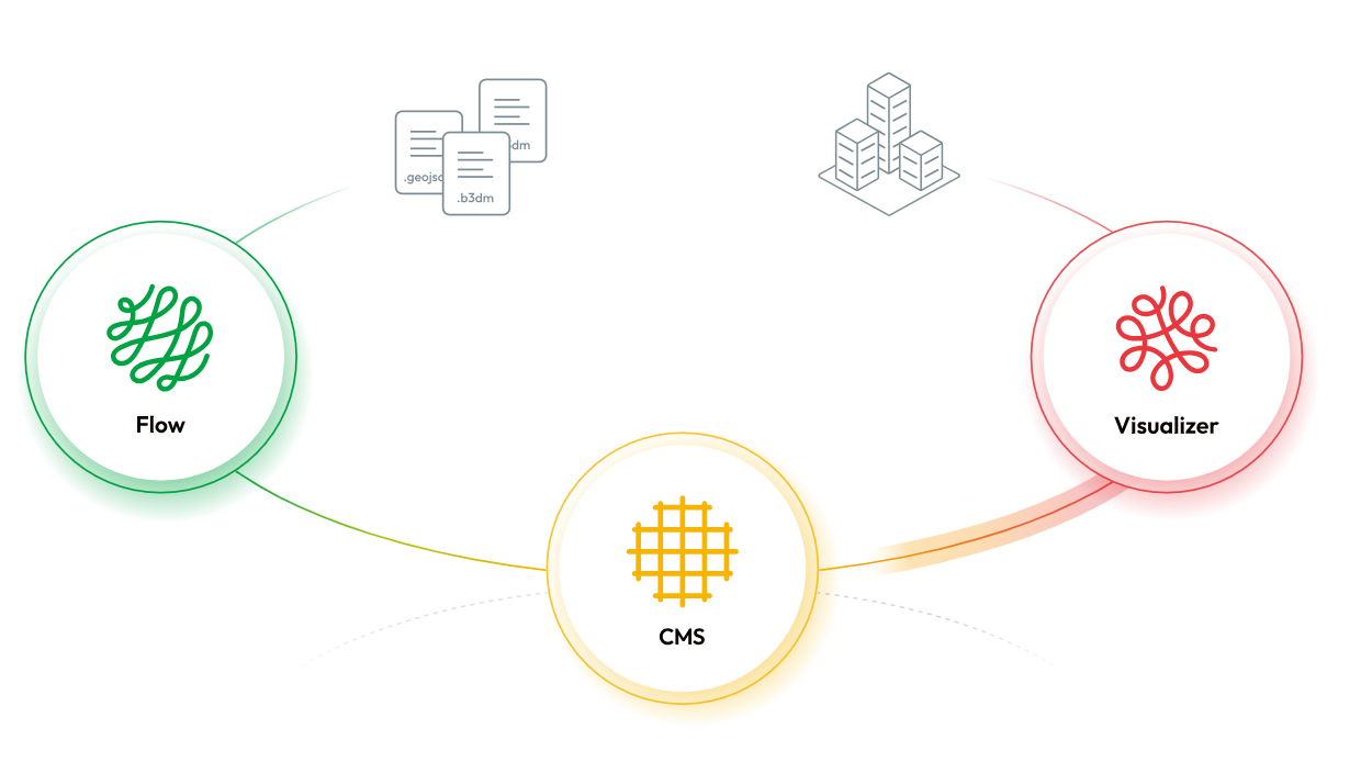
The Re:Earth Ecosystem is an integrated, open-source digital twin platform composed of three interoperable tools: Re:Earth Flow, Re:Earth CMS, and Re:Earth Visualizer. Together, they enable organizations to process, manage, visualize and publish geospatial data without coding or specialized infrastructure.
The ecosystem covers the full geospatial data lifecycle. Re:Earth Flow automates data conversion and processing workflows; Re:Earth CMS provides a no-code environment for managing and publishing spatial databases; and Re:Earth Visualizer enables interactive 2D/3D visualization and storytelling through a browser-based interface. Built under open-source licenses and accessible via web browsers, the ecosystem removes cost and technical barriers while enabling scalable digital twin applications across cities and countries.
The ecosystem lowers barriers to geospatial technology by eliminating licensing costs, software installation requirements and advanced coding skills. Browser-based interfaces allow non-technical government staff, NGOs and local communities to independently manage and publish spatial data.
By enabling no-code workflows across the entire data lifecycle—from processing to visualization—the platform allows organizations with limited technical capacity to participate in digital governance and open data ecosystems. This approach supports inclusion by empowering local institutions, municipalities and crisis-affected communities to use spatial data for planning, disaster response and citizen engagement without reliance on specialized engineering teams.
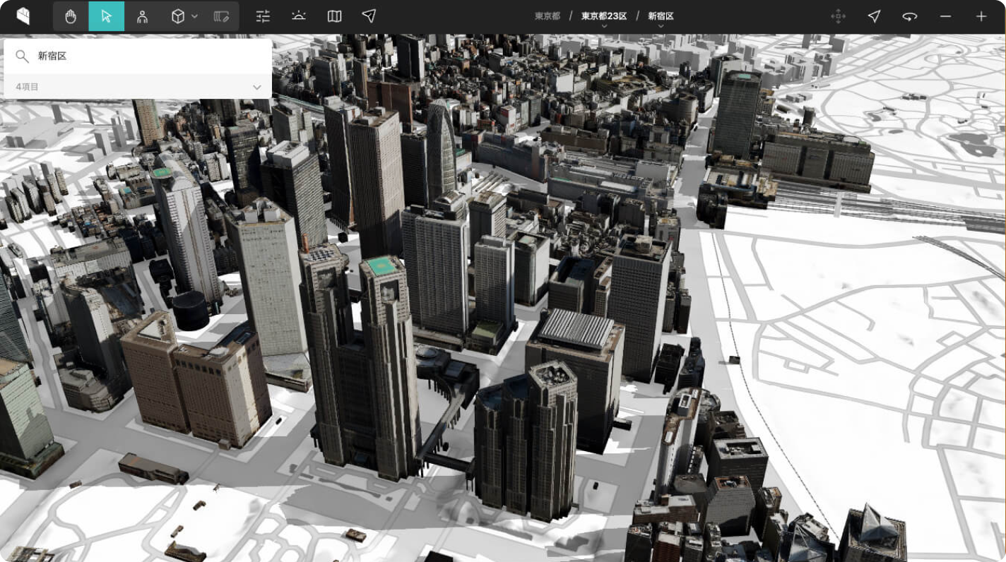
The Re:Earth Ecosystem serves as the core digital infrastructure behind Japan’s PLATEAU initiative, a pioneering 3D urban city modelling project used for urban planning. The tool supports 300+ municipalities and manages approximately 30TB of open 3D city model data covering around 18 million buildings and 38.4 percent of Japan’s population. The platform enables non-technical municipal staff to independently upload, manage, quality-check and publish spatial datasets, transforming a centralized system into a distributed, municipality-driven open data ecosystem. The ecosystem has supported 44+ pilot applications across urban planning, disaster prevention and citizen participation. It has also been used by the United Nations Institute for Training and Research (UNITAR) to deliver digital skills training for Ukrainian women evacuees. Automated data pipelines replaced manual processing workflows, significantly reducing technical requirements for publishing digital twin data.
The Re:Earth Ecosystem will be deployed to Latin America and the Caribbean through the Transformational Startups and Business Acceleration for the SDG Agenda (TSUBASA) programme, led by the Japan International Cooperation Agency (JICA) and the International Development Bank (IDB). It will also support the EU-led Digital Twin for Reconstruction of Ukraine, in partnership with the United Nations Industrial Development Organization (UNIDO).
Future development includes multilingual support, expanded geospatial format compatibility (including the urban data modelling formats CityJSON and IFC), and deployment through UNDP Country Offices in developing contexts. The roadmap also includes pursuing digital public goods certification, expanding municipal application templates such as hazard mapping and citizen reporting systems, and strengthening global community engagement through events such as FOSS4G 2026, the flagship conference for open-source geospatial software, which will be held this year in Hiroshima.